
Kanchenjunga Circuit Trek Safety Guide: Altitude, Trail Conditions & Emergency Planning
One of the most common questions we receive from prospective trekkers is, "Is the Kanchenjunga Circuit Trek safe?" It is a fair question, particularly given the region's remoteness, high altitude and reputation as one of Nepal's last true wilderness adventures.
The simple answer is yes. The Kanchenjunga Circuit Trek is a safe and rewarding journey for well-prepared trekkers who approach it with realistic expectations, good physical fitness and an itinerary that allows proper acclimatisation. Like any high-altitude trek in the Himalayas, the risks are real, but they are also well understood and, in many cases, preventable.
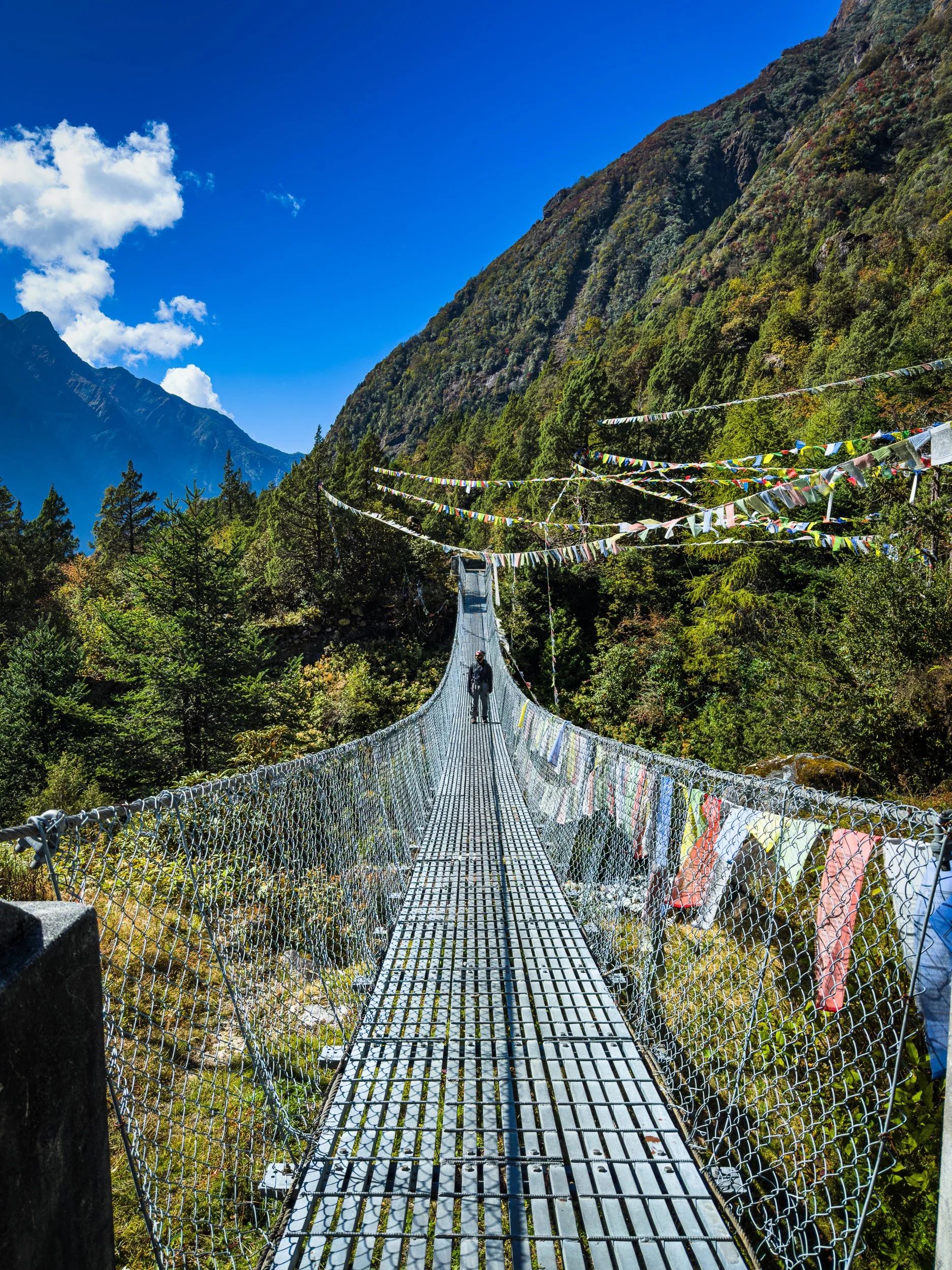
The suspension bridge after the village of Phale, before we arrive onto Ghunsa. At the end of this suspension brige, we also see the trail for the fabled Nango La, part of ‘The Great Himalayan Trail’, Autumn 2025
From our experience leading expeditions in the Kanchenjunga region, the greatest challenges rarely come from the mountains themselves. Instead, they arise from rushing the itinerary, underestimating the effects of altitude, carrying inadequate equipment, or making poor decisions when weather or trail conditions change. A conservative approach, experienced local leadership and the willingness to adapt to mountain conditions are often the biggest contributors to a safe and enjoyable trek.
In this guide, we'll explain the key safety considerations for the Kanchenjunga Circuit Trek, including altitude sickness, trail conditions, weather, emergency communication, helicopter evacuation protocols and the practical measures we take to minimise risk throughout the journey.
Is the Kanchenjunga Circuit Trek safe?
Despite its reputation as one of Nepal's most remote trekking destinations, we consider the Kanchenjunga Circuit Trek to be a safe high-altitude adventure when it is approached responsibly. The trail itself does not require technical climbing skills, ropes or mountaineering experience. However, its remoteness means that self-sufficiency, patience and careful planning become far more important than on the more commercial trekking routes of Everest or Annapurna.
Unlike regions with road access or frequent settlements, much of the Kanchenjunga Circuit follows isolated mountain valleys where evacuation options are limited to either retracing your steps on foot or, when necessary and weather permits, a helicopter evacuation. For this reason, prevention is always better than rescue. Proper acclimatisation, pacing, hydration and listening to your guide's advice remain the most effective ways to reduce risk.
The majority of trekkers who complete the circuit experience nothing more than the normal physical demands associated with trekking at altitude. By allowing sufficient acclimatisation, carrying appropriate equipment and remaining flexible with the itinerary, most common issues can be addressed long before they develop into serious problems.
Safety & Logistics Overview
• Highest Sleeping: Lhonak (4,780m)
• High Camps: 4 Nights above 4,000m (Khambachen & beyond) and 1 Night at Selele High Camp
• Passes (4,700m max): Selele La, Mirgin La, Sine Lapcha La
*Note: No mule or horse rescue available due to rugged trail geometry.
Exposed Trails & Hazards to Watch For
• Lhonak to Pangpema: High mountain scree, narrow ledges, and active rockfall hazards.
• Torongden to Kengsra: Steep, exposed descent sections demanding focused foot placement.
The Most Common Safety Considerations
Rather than one major hazard, the Kanchenjunga Circuit Trek requires trekkers to understand several smaller risks that naturally come with travelling through a remote Himalayan environment.
High Altitude – Spending multiple nights above 4,000 metres increases the risk of Acute Mountain Sickness (AMS), making gradual acclimatisation essential.
Remote Trail Conditions – Landslide-prone sections, steep ascents, river crossings and long walking days require careful footing and good physical preparation.
Rapidly Changing Mountain Weather – Snowfall, strong winds and cold temperatures, particularly around Selele Pass and Pangpema, can alter trail conditions with little notice.
Limited Medical Facilities – Small health posts are available in some villages, but advanced medical care is only accessible after evacuation to Kathmandu.
Limited Connectivity – Mobile network coverage is intermittent throughout much of the trek. Satellite communication devices remain the most reliable method for emergency communication in remote sections.
Fortunately, every one of these challenges can be managed through proper preparation, experienced leadership and sensible decision-making. Throughout the remainder of this guide, we'll explain each of these aspects in greater detail, along with the practical safety measures we recommend before and during the trek.
High Altitude & Acclimatisation
At 5,143 metres, the Kanchenjunga Circuit Trek reaches an altitude where every trekker is susceptible to altitude sickness, regardless of age or fitness level. While being physically fit certainly helps with the demands of long trekking days, it does not make anyone immune to the effects of reduced oxygen at higher elevations.
The key to a safe ascent is gradual acclimatisation. Our itinerary has been carefully designed to allow your body sufficient time to adapt as we gain altitude, reducing the likelihood of serious altitude-related illnesses while improving your overall trekking experience.
To support this process, we include two dedicated acclimatisation days during the trek:
Ghunsa (3,595m) – Acclimatisation hike to Ghunsa View Point, followed by a return to sleep at the same elevation.
Khambachen (4,050m) – Acclimatisation hike towards Jannu (Kumbhakarna) View Point, again returning to sleep at Khambachen.
This approach follows the widely accepted principle of "Climb High, Sleep Low," allowing your body to adapt more effectively before moving higher into the valley.
Recognising Altitude Sickness
Most cases of Acute Mountain Sickness (AMS) begin with mild symptoms such as headache, loss of appetite, nausea, unusual fatigue or difficulty sleeping. When recognised early, these symptoms can usually be managed with rest, hydration, medication and careful observation.
If symptoms worsen or do not improve, more serious conditions such as High Altitude Cerebral Oedema (HACE) or High Altitude Pulmonary Oedema (HAPE) may develop. Although uncommon, both conditions are medical emergencies and require immediate descent and evacuation.
Our Approach to Altitude Safety
Preventing altitude sickness is always preferable to treating it. Throughout the trek, our guides actively monitor every participant for early signs of altitude-related illness rather than waiting for symptoms to become severe.
Our guides are trained to assess trekkers using the Lake Louise Scoring (LLS) System, an internationally recognised method for evaluating Acute Mountain Sickness. Depending on the severity of symptoms, we may recommend:
Continued observation and hydration
Rest with medication where appropriate
A delayed ascent until symptoms improve
Immediate descent if symptoms persist or worsen
Where appropriate, Diamox (Acetazolamide) may be used as a preventative or supportive medication. However, medication should never replace proper acclimatisation or encourage a faster ascent.
Should a participant require descent, the itinerary allows us to backtrack to lower elevations, with Ghunsa being the most practical location for continued monitoring and recovery.
Medical Support in the Region
Although the Kanchenjunga region is remote, basic medical support is available in Ghunsa Health Post, which is seasonally staffed and equipped with an oxygen concentrator for initial treatment and stabilisation.
For more serious altitude-related illnesses or medical emergencies, helicopter evacuation remains the safest and most appropriate option, subject to weather conditions and flight availability. Every participant should therefore have high-altitude trekking insurance that includes helicopter evacuation before undertaking the trek.
Trail Conditions on the Kanchenjunga Circuit Trek
One of the defining characteristics of the Kanchenjunga Circuit Trek is its constantly changing terrain. Unlike the well-developed trekking routes of Everest Base Camp or the Annapurna Circuit, the trails in the Kanchenjunga Conservation Area remain largely untouched, rugged and shaped by the natural forces of the Himalayas.
Throughout the trek, you will encounter everything from dense subtropical forests and narrow cliff-side traverses to glacial moraine, scree slopes, boulder fields and high mountain passes. The trail itself is not technically difficult, but it demands good balance, sure footing and the ability to hike confidently on uneven mountain terrain.
Another important consideration is that trail conditions on the Kanchenjunga Circuit Trek change every year. Monsoon rains, landslides, rockfall and seasonal snowfall frequently reshape sections of the route. As a Trek Leader, I assess these changes every season and adjust our route where necessary to prioritise safety over speed. While maps provide a general reference, local knowledge and current trail conditions are often far more valuable in remote regions like Kanchenjunga.
Section-by-Section Trail Conditions
Field assessments, hazards, terrain details, and operational guide notes.
- Terrain: Post-2025 flood repairs; temporary cliff-side traverses and rope crossings over Ghunsa Khola.
- Protocol: Maintain strict distance between trekkers; move steadily without rushing.
- Low Trail: Shorter river path; restored flood section, more exposed.
- High Trail: Safe alternative bypass adding walk time during bad weather or trail instability.
- Terrain: Subtropical forest, stone staircases, narrow traverses, landslide-prone slopes.
- Requirements: Non-technical walking; demands disciplined pacing and deliberate foot placement.
- Terrain: Shift to open alpine valley; rocky trails, exposed traverses, glacial stream crossings.
- Key Risk: High fatigue combined with thinning air; requires sustained focus despite easy paths.
- Hazards: High rockfall zone near Ramdang, frequently triggered by grazing Blue Sheep above.
- Terrain: Heavy glacial moraine and loose boulder fields across the valley floor.
- Terrain: Lateral glacier moraine, unstable scree slopes, large boulder navigation.
- Gear Tip: Trekking poles are essential for stability on scree and joint relief on return.
- Terrain: 4–5 hour continuous climb through forest to steep alpine hillside traverses.
- Pacing: Slow, rhythmic step-pacing prevents premature exhaustion before pass crossing.
- Crossings: Selele La, Mirgin La, Sinion La (~4,700m max). Snow obscures path quickly.
- Logistics: Carry full day's water and high-energy snacks from camp (no water on trail).
- Terrain: Rugged, gradual alpine valley approach beneath Kanchenjunga South Face.
- Preparation: Zero teahouse facilities past Ramche; self-sufficiency required for cold/food.
- Terrain: Long steep downhill, wet uneven stone steps, riverside paths, exposed drops.
- Risk Factor: High risk of slips and joint injury caused by late-trek leg fatigue.
Essential Gear Checklist for Terrain
• Support: Adjustable trekking poles for loose scree and steep descents.
• Traction: Microspikes for high pass crossings during fresh snow/ice.
Sekathum – Itahari
Following the destructive 2025 monsoon floods, parts of the original trail between Sekathum and Itahari were washed away by the Ghunsa Khola. Local communities have done an incredible job restoring access by constructing temporary cliff-side traverses and rope-assisted crossings.
Although these reconstructed sections are generally safe, they remain exposed in places and require careful footing. During these crossings, we maintain adequate spacing between trekkers and move steadily without rushing.
Guide's Note: These temporary trails are a reminder of how dynamic the Himalayan landscape can be. Trail conditions may continue to evolve from one trekking season to the next.
Itahari – Lamatar
There are currently two possible routes between Itahari and Lamatar.
The shorter trail follows the river and passes through sections that were reconstructed after the monsoon damage. While perfectly passable under normal conditions, it remains more exposed in several places.
Whenever weather or trail stability raises any concern, I prefer taking the higher alternative trail. Although it adds some extra walking time, it generally offers a safer and more comfortable option.
For me, choosing the safer trail is always preferable to saving an hour of hiking.
Lamatar – Thangyam – Gyabla – Ghunsa
As the Kanchenjunga Circuit Trek gradually leaves the lower valleys behind, the trail passes through dense forests, bamboo groves, cardamom plantations and traditional villages before climbing steadily towards the alpine landscape around Ghunsa.
This section features numerous steep ascents and descents, uneven stone staircases, narrow traverses and occasional landslide-prone slopes. None of these require technical climbing, but they do reward steady pacing and good foot placement.
Many trekkers describe this section as physically demanding rather than technically difficult.
Ghunsa – Khambachen
Beyond Ghunsa, the landscape begins changing dramatically as dense forests gradually give way to alpine terrain.
The trail becomes progressively rockier with longer exposed traverses, glacial streams and increasing altitude. While the walking remains relatively straightforward, fatigue combined with thinner air means maintaining concentration becomes increasingly important.
This is also where the scenery becomes noticeably more dramatic, with Jannu (Kumbhakarna) dominating the skyline for much of the day.
Khambachen – Lhonak
If there is one section of the Kanchenjunga Circuit Trek where I consistently remind trekkers to stay alert, it is the approach between Khambachen and Lhonak.
Shortly before reaching Ramdang, the trail traverses beneath steep rocky slopes that are occasionally affected by natural rockfall. One of the most common causes is movement from herds of Blue Sheep grazing high above the trail.
During one of my expeditions in Autumn 2025, I experienced a particularly close call when several rocks were dislodged by a herd playing on the cliffs above us. Fortunately, everyone passed safely, but it reinforced the importance of remaining vigilant in this section.
Whenever we cross this area, I encourage trekkers to move efficiently, avoid unnecessary stops for photographs and remain aware of any movement or sounds from the slopes above.
The trail itself crosses extensive boulder fields and glacial moraine, requiring careful footing throughout.
Guide's Note: Rockfall is unpredictable. If your guide asks you to continue walking through an exposed section, it is usually because stopping increases your time beneath the hazard.
Lhonak – Pangpema (Kanchenjunga North Base Camp)
The hike to Pangpema (Kanchenjunga North Base Camp) is undoubtedly one of the highlights of the entire trek, but it is also among the most physically demanding.
The trail follows the edge of the Kanchenjunga Glacier, crossing loose scree, unstable moraine and large boulders while gradually ascending towards 5,143 metres.
There is no technical climbing involved, but the combination of altitude, uneven terrain and repeated ascents and descents demands patience and careful foot placement.
This is one of the days where trekking poles become invaluable, both for stability and for reducing strain on your knees during the return journey to Lhonak.
Ghunsa – Selele High Camp
The climb from Ghunsa to Selele High Camp is a sustained ascent of approximately four to five hours, gradually climbing through rhododendron forests before emerging into alpine terrain.
Several sections traverse steep hillsides where careful footing is required. Although the trail is well established, fatigue towards the end of the climb often makes this section feel more demanding than its technical difficulty suggests.
A slow, consistent pace is far more effective than rushing the climb.
Selele High Camp – Tseram
Crossing Selele La, Mirgin La and Sinion La is one of the most spectacular days on the Kanchenjunga Circuit Trek, offering panoramic views extending towards Makalu and, on exceptionally clear days, even Mount Everest on the distant horizon.
In stable weather, the route is generally straightforward to follow. However, fresh snowfall can quickly obscure the trail, making navigation considerably more difficult.
The route crosses extensive boulder fields before descending onto loose scree above Tseram. During snowy or icy conditions, I strongly recommend carrying microspikes, which provide significantly better grip and confidence on frozen ground.
Another consideration is hydration. Apart from a small seasonal teahouse near Mirgin La, there are no reliable places to refill water. Every trekker should leave Selele High Camp carrying sufficient water and snacks for the entire crossing.
Tseram – Ramche – Oktang (Kanchenjunga South Base Camp)
The trail to Kanchenjunga South Base Camp (Oktang) follows rugged alpine terrain beneath the immense south face of Kanchenjunga.
Although the elevation gain is more gradual than the northern approach, the day remains physically demanding due to its length, altitude and exposed terrain.
Because there are very limited facilities along this route, carrying adequate water, warm clothing and high-energy snacks is essential.
Tseram – Kengsra – Ranipul
Many trekkers assume the final descent will be the easiest day simply because it is mostly downhill. In reality, this is often one of the most demanding days of the entire Kanchenjunga Circuit Trek.
The trail includes long, steep descents, temporary riverside paths, exposed traverses and countless uneven stone steps that become particularly slippery after rain. Much of the route passes through dense forest with little to no mobile network coverage, making careful decision-making even more important.
One incident that has stayed with me occurred on this descent before reaching Kengsra, where a client slipped on the trail and suffered a shoulder dislocation. Although we managed the situation successfully, it reinforced a lesson I now repeat on every expedition: the final days deserve the same level of concentration as the first.
Fatigue, rather than difficult terrain, is often the biggest contributor to accidents during long descents.
Guide's Note: The trails on the Kanchenjunga Circuit Trek demand respect rather than fear. With proper hiking boots, trekking poles, a steady pace and the guidance of an experienced leader, these rugged mountain paths become one of the most rewarding aspects of the journey. The remoteness, changing landscapes and raw nature of the trail are precisely what make Kanchenjunga one of Nepal's last truly authentic trekking experiences.
Weather & Seasonal Hazards in Kanchenjunga Circuit Trek
Weather in the Kanchenjunga Circuit Trek can change quickly, particularly once we ascend beyond Ghunsa into the alpine environment. Clear mornings may gradually give way to cloud cover, snowfall or strong afternoon winds, especially around Selele Pass and Kanchenjunga North Base Camp.
Light snowfall is a normal part of trekking during early Spring and late Autumn, and we may continue after carefully assessing trail conditions and visibility. However, in the event of heavy snowfall, particularly above Ghunsa, we will not continue into terrain where navigation becomes difficult or avalanche and slip hazards increase significantly.
Likewise, during periods of prolonged rainfall or after heavy monsoon events, we avoid sections affected by landslides or flooding whenever alternative routes are available. Safety always takes priority over maintaining a fixed itinerary.
Guide's Recommendation: I strongly recommend keeping 2–3 buffer days in your travel plans. Weather delays affecting domestic flights, road transport or trail conditions are not uncommon in Eastern Nepal, and additional flexibility allows us to make safer decisions without feeling pressured by a tight schedule.
Wildlife & Pack Animals
The Kanchenjunga Conservation Area is one of the world's recognised biodiversity hotspots, making wildlife encounters one of the unique experiences of this trek.
Although sightings are never guaranteed, it is common to encounter Blue Sheep grazing on the alpine slopes above Khambachen and Lhonak. If we are particularly fortunate, we may also spot the elusive Red Panda, while sightings of the Snow Leopard remain exceptionally rare and memorable.
Large predators such as Himalayan Black Bears inhabit the region, but encounters along the trekking trail are extremely uncommon.
One animal you are almost certain to encounter, however, is the yak.
Yaks are an essential part of local mountain life and are widely used to transport supplies, particularly between the southern and northern sections of the circuit where terrain permits.
Guide's Note:Yaks always have the right of way. When meeting a caravan, always move to the uphill side of the trail, give the animals plenty of space, and follow your guide's instructions. Never stand on the exposed downhill edge while allowing a yak train to pass.
Food & Water Safety in Kanchenjunga Circuit Trek
Maintaining proper hydration and nutrition is one of the simplest yet most effective ways to stay healthy during the Kanchenjunga Circuit Trek.
I recommend carrying at least 2 litres of drinking water throughout the day and treating all drinking water using purification tablets, filters or UV purification devices. Even water from mountain streams should be purified before consumption.
Good hand hygiene is equally important. Washing or sanitising your hands before every meal significantly reduces the risk of gastrointestinal illness during the trek.
When choosing meals, I generally recommend eating freshly prepared cooked food and avoiding raw vegetables or meat at higher elevations. Local staples such as Dal Bhat, noodles, fried rice, potatoes and soups are reliable, nutritious and well suited to long days on the trail.
Energy bars, trail snacks and electrolyte tablets are also worth bringing from Kathmandu, as they become increasingly expensive in the mountains due to the remote logistics of supplying the region. While snacks, chocolates and basic supplies are available in villages such as Ghunsa and some higher teahouses, prices are often two to three times higherthan in Kathmandu.
If you'd like a detailed breakdown of food prices and other hidden expenses, please refer to our Kanchenjunga Circuit Trek Cost Guide.
EMERGENCY PLAN OF ACTION & EVACUATION PROTOCOL FOR KANCHENJUNGA CIRCUIT TREK
Medical Response & Evacuation Protocol
Step-by-step decision framework, field triage, helicopter coordination, and insurance assistance.
- Physical Trauma: Inspection for structural injury, fractures, or mobility impairment.
- Altitude Assessment: Quantitative evaluation using the standard Lake Louise Score system.
- Environmental Factors: Assessment of immediate weather stability and surrounding trail risks.
- Capability Check: Evaluating trekker's ability to safely continue under own power.
- Rest & Observation: Mandatory pause to monitor vital signs and symptom progression.
- First-Aid & Medication: Administration of approved field meds or oxygen support.
- Resting Schedule: Pausing ascent for additional acclimatisation rest days.
- Immediate Descent: Tactical retreat to lower elevation if altitude illness is suspected.
- Local Medical Referral: Direct transport to Ghunsa Health Post for clinical evaluation.
- Symptoms Improve: Resume trek at a modified pace with continuous health checks.
- Symptoms Worsen: Immediate forced descent to safer altitude—no exceptions.
- Insurance Contact: Notify insurance emergency dispatch via satellite device.
- Operator Logistics: Coordinate flight availability with helicopter charter team.
- Government Approvals: Secure mandatory flight clearance permits for Restricted Area zones.
- Emergency Contacts: Brief designated family/emergency contact (with trekker consent).
- Helicopter Transport: Aerial transfer from trail landing site to Kathmandu helipad.
- Hospital Admission: Immediate transfer to specialized medical facility.
- Comprehensive Care: Advanced diagnostics, physician assessment, and treatment.
- Medical Reports: Fully documented physician charts and treatment records.
- Health Post Referrals: Official field triage & health post documentation.
- Invoices & Receipts: Detailed helicopter charter and hospital billing files.
- Incident Reports: Formal Trek Leader logbook reports for insurance submission.
Adverse Weather Contingency Protocol
- Assisted Walking: Dual-guide support for light mobility injuries.
- Stretcher / Mountain Gurney: Rigged carry for severe non-ambulatory cases.
- Traditional Woven Basket (Doko): Specialized porter carry for narrow terrain.
- Local Mobilization: Enlisting village support to ensure continuous relay teams.
Guide's Field Note
In the mountains, patience is sometimes part of the rescue.
During one expedition, a client developed an acute sinus infection in Ghunsa that required helicopter evacuation. Due to persistent poor weather, we waited approximately 72 hours before flying safely to Kathmandu.
On another expedition, a client suffered a shoulder dislocation on the descent before Kengsra. With helicopters unable to land immediately, our porters manually carried the client to the nearest teahouse where we provided pain management and monitoring before a helicopter evacuation was completed approximately 24 hours later.
These experiences reinforce an important lesson: while helicopter rescue is an invaluable resource in the Kanchenjunga region, it should never be expected to arrive immediately. Weather always has the final say in the Himalayas, which is why conservative decision-making, early intervention and carrying comprehensive high-altitude trekking insurance with helicopter evacuation remain essential.
Our philosophy has always been simple: prevention is better than evacuation. We make conservative decisions, monitor every participant proactively, and adapt our itinerary whenever mountain conditions require it. Reaching Kanchenjunga North or South Base Camp is never more important than returning home safely. The mountains will always be there, and our responsibility is to ensure that every journey ends with great memories—not unnecessary risks.
Our Top 10 Safety Tips for the Kanchenjunga Circuit Trek
After leading multiple expeditions in the Kanchenjunga region, I've realised that most problems on the trail are preventable. Success on this trek is rarely about being the strongest hiker; it's about making good decisions consistently over three weeks in the mountains.
Here are the safety principles I share with every participant before we begin the trek.
1. Respect the Altitude
Fitness does not protect you from altitude sickness. Listen to your body, communicate even mild symptoms to your guide, and never try to "push through" a headache or nausea.
2. Trust the Acclimatisation Process
The acclimatisation days in Ghunsa and Khambachen are not rest days—they are one of the most important parts of the itinerary. They give your body time to adapt and greatly reduce the risk of altitude-related illnesses.
3. Trek at Your Own Comfortable Pace
There is no prize for reaching the teahouse first. Walk at a pace where you can comfortably hold a conversation, take regular breaks, and allow your breathing to settle naturally. Consistency is far more important than speed.
4. Stay Hydrated Throughout the Day
Carry at least 2 litres of purified drinking water every day. Dehydration not only affects your energy levels but can also make the symptoms of altitude sickness feel worse. Have at least 1 ltr of Water with Electrolytes
5. Invest in Proper Footwear
A good pair of broken-in hiking boots and trekking poles will do more for your safety than almost any other piece of equipment. Much of the Kanchenjunga Circuit Trek involves uneven terrain, loose rocks and long descents where stability is essential.
6. Expect the Mountains to Change Your Plans
Weather, trail conditions and transportation in the Himalayas are never guaranteed. Keep 2–3 buffer days in your travel itinerary and be prepared to adapt when conditions require it.
7. Always Give Way to Yaks
Yak caravans are part of everyday life in the Kanchenjunga region. Move to the uphill side of the trail, give them plenty of space and never stand on the exposed edge while they pass.
8. Carry Comprehensive Trekking Insurance
Make sure your policy specifically covers high-altitude trekking above 5,000 metres and helicopter evacuation. Read the policy carefully before travelling and understand the claims process before you begin the trek.
9. Communicate Early
Whether it's a headache, blister, stomach discomfort or unusual fatigue, let your guide know as early as possible. Small issues are often easy to manage; delayed reporting can quickly turn them into larger problems.
10. Remember Why You Came
The goal of the Kanchenjunga Circuit Trek isn't simply to reach Pangpema or Oktang. It's to experience one of the last truly remote mountain regions in the Himalayas safely, responsibly and with memories you'll carry long after the trek is over.
Guide's Final Note: The mountains don't reward rushing—they reward patience. Some of the best days on the Kanchenjunga Circuit aren't the highest or the hardest; they're the quiet moments shared over a cup of tea in a small village, a sunrise over Jannu, or simply walking through a landscape that has remained remarkably unchanged for generations.
Frequently Asked Questions for Safety in Kanchenjunga Circuit Trek
-
No. The Kanchenjunga Circuit Trek is not considered a dangerous trek when undertaken with a realistic itinerary, proper acclimatisation and an experienced guide. Like any trek above 5,000 metres, the primary risks are altitude sickness, changing weather and rugged trail conditions. With sensible planning and conservative decision-making, these risks can be managed effectively.
-
From our experience, altitude sickness and trail injuries are the most important consideration, followed by long, rugged trail conditions and rapidly changing mountain weather. These are exactly why we prioritise acclimatisation, monitor trekkers daily using the Lake Louise Scoring System, and adapt the itinerary whenever necessary.
-
Yes. Helicopter evacuation is possible from many parts of the Kanchenjunga Circuit Trek, but flights are entirely dependent on weather, visibility and suitable landing conditions. Delays of 24–48 hours, and occasionally longer, are possible during periods of poor weather.
-
Absolutely. Every participant should have high-altitude trekking insurance that specifically covers trekking above 5,000 metres and helicopter evacuation. Because this is a remote trekking region, evacuation by road is not possible once you are deep into the circuit.
-
As a Restricted Area in Nepal, the Kanchenjunga Circuit Trek cannot be undertaken completely independently. A registered trekking guide is mandatory, and special permit regulations apply. Trekking with an experienced guide not only fulfils legal requirements but also provides invaluable local knowledge, emergency support and informed decision-making throughout the journey.
-
Previous high-altitude trekking experience is highly recommended. Trekkers who have completed multi-day hikes above 4,000 metres generally adapt more comfortably to the physical and mental demands of the Kanchenjunga Circuit Trek. Good physical fitness, patience and the willingness to trek at a steady pace are equally important.
If you're preparing for the trek, we recommend exploring the rest of our Essential Trek Information series. You'll find detailed guides covering Kanchenjunga Circuit Trek Difficulty, Permits, Costs, Packing List, and Internet & Connectivity, each written from first-hand experience operating expeditions in the region.
